SonarWiz Geodetic Library Update
SonarWiz 7.09.05 introduces a new geodetic library. The new library uses a completely new database of coordinate refence systems (CRS) and a new calculation engine under the hood with updated support for modern dynamic datums, grid-based transformations, datum ensembles and derived projected coordinate reference systems.
The following FAQ will answer questions about our motivation for switching projection engines and what this change will mean for new and existing SonarWiz users.
Frequently Asked Questions
Why did you change the geodetic library?
We had several reasons:
The last major update to the SonarWiz geodetic library was in 2010. In the intervening years, national survey offices have introduced hundreds of updated reference systems and datum, some of which use advanced transformation algorithms that were not fully supported by our older engine.
We wanted a library that produced more standards compliant georeferencing. This makes it easier to take SonarWiz outputs into your downstream GIS and CAD software.
We wanted a library that was widely used and supported and easy to update as needed. This allows CTI Engineers to focus on sonar processing, our core business
Are projects created in older versions of SonarWiz compatible with SonarWiz 7.09.05 and newer?
Yes, you can go backwards and forwards between versions, but you will have to redefine your project coordinate system manually whenever you switch engines.
The two different geodetic engines use different names (aka spatial reference IDs) for the same coordinate systems. For example, take a project that is in WGS 84 / UTM zone 17N.
In SonarWiz 7.09.04 and older: UTM84-18N
In SonarWiz 7.09.05 and newer: EPSG:32618
So long as there is a matching coordinate system in both versions of SonarWiz, you should be able to migrate between versions.
What happens when I open an existing project in SonarWiz 7.09.05 or newer?
When you open an existing project created with the old geodetic engine, SonarWiz 7.09.05 and newer will present a Geodesy Update Warning:
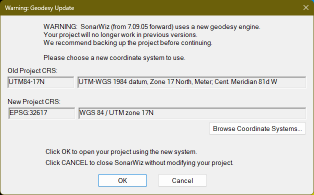
In order to continue opening the project in SonarWiz 7.09.05+, you will need to specify the new coordinate system to use. You want to match the new CRS as closely as possible with the old one. In most common cases, there is an obvious match, but some care should be taken to match the datum, ellipsoid and units exactly.
If you click OK, the new SRID will be written into the project files and the project may no longer be compatible with prior versions of SonarWiz (see below).
We recommend you make a backup of your projects before opening them in SonarWiz 7.09.05 in case something goes wrong.
What happens if I want to roll back to an older version of SonarWiz before the geodetic update?
Older versions of SonarWiz will not recognize the spatial reference ID (SRID) of projects created in SonarWiz 7.09.05 and newer. You will see the new CRS listed in the Coordinate System properties of the project, but SonarWiz will behave erratically because it doesn’t recognize the new name:
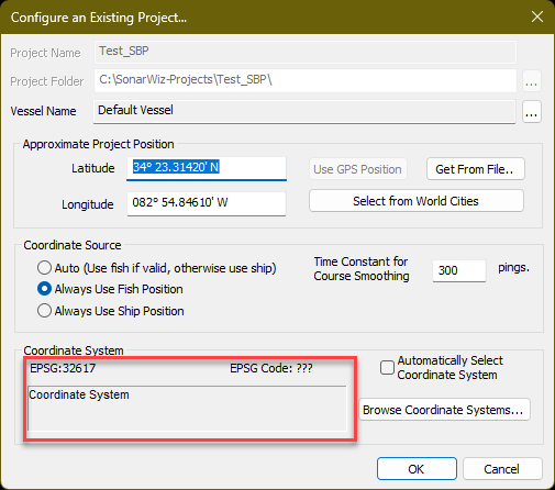
Before using the project, you must open the Project Properties window and select a compatible coordinate system from the old database.
We have not extensively tested rolling back to make sure that all functionality is working as expected. We strongly recommend that you back up your project before rolling back to an older version.
Are custom coordinate system files created for SonarWiz Version 7.09.04 and earlier compatible with SonarWiz 7.09.05 and newer?
No. They are not compatible.
SonarWiz 7.09.04 and older, and SonarWiz 7.09.05 and newer, use incompatible mechanisms for storing and exchanging custom coordinate systems.
In order to migrate a project between those versions, you will need to manually add the custom CRS to your target SonarWiz version. Once the custom coordinate system is available, you can promote or roll back the project exactly as with the built-in systems described previously.
Please reach out to the CTI Help Desk if you have questions about this.
Why does my WKT definition change in exported GeoTiffs and PRJ files?
SonarWiz uses a Global Mapper (GM) library for all exported image operations. GM uses its own geodetic engine, which is compatible with SonarWiz, but not identical to it. When SonarWiz saves a GeoTiff, it is Global Mapper that saves the PRJ file and embeds the WKT in the GeoTiff images.
We often notice differences between the SonarWiz WKT and the Global Mapper WKT output. Usually, the difference is in the descriptive fields not the numeric fields, but if you discover a discrepancy that causes a significant data offset, please let us know.
The CRS I want isn’t listed; how do I create a custom CRS?
If your chosen spatial refence id (SRID) is not listed in the built-in database, you can create a new CRS using the full power of the new PROJ-based projection engine. We are happy to help you create new CRS. Please follow this link to request a new CRS:
On this page:
Related content: